Idle Valley Nature Reserve, 28th May 2023


 Sue's 8-mile walk started in the Idle Valley Nature Reserve, created from a former gravel quarry and abandoned power station settling lagoons and now managed by Nottinghamshire Wildlife Trust.  The walk took us around the nature reserve, beside rivers and lakes to Lound Village and back.


Thirty to forty years ago, fly ash from nearby coal-fired power stations was trucked into the Idle Valley and formed into the hills and lakes seen today. More than six million tonnes of it. Then, with help from the European Regional Development Fund, the Alliance SSP and the Heritage Lottery Fund, it was carefully rewilded into what is now one of England's most important wildlife reserves, home to vast over-wintering flocks of wildfowl and many rare species, and popular with birdwatchers, fishermen, walkers, foragers and families.

Now they want to dig it all up again, so watch this space!


Idle Valley Visitor Centre (on a brighter day)

The start at the Visitor Centre

Entering the Reserve on boardwalks


River Idle

River Idle catchment


Although only 10 miles long, the River Idle drains a significant area (500 square miles) of north Nottinghamshire with contributions from as far away as Kirkby, Huthwaite, Bolsover and Rainworth (Rivers Maun, Meden, Poulter and Rainworth Water)

Originally, it flowed northwards to meet the River Don but was diverted eastwards by drainage engineers in 1628 and now meets the (tidal) Trent near West Stockwith.  Two sluice gates and several large pumps are located there and used to control river levels and navigation and prevent flooding

Coffee stop on Chainbridge Lane

Some of the many birds we expected to see ...

... but didn't

Lunch at Lound Village Green, Lound Hall in the background

The odd orchid (actually two were seen)


Londonthorpe Woods and Belton Park, 25th May 2023


 In October, we are proposing a tour of the Woodland Trust's Londonthorpe Woods and National Trust's Belton Park near Grantham, guided by a volunteer from the National Trust.  It would start either at the WT car park on Five Gates Lane or at Belton House.  The area has an interesting past which the guide will describe:  in August 1914, at the onset of WWI, the 3rd Earl Brownlow loaned Belton Park to Lord Kitchener as a training camp for the 11th (Northern) Division. The park hosted 13,000 volunteer soldiers initially in bell tents and later in purpose built huts.  


The camp also had a narrow-gauge light railway which after the war was bought by farmers in Lincolnshire and the fens for use in their fields to transport their crops, potatoes in particular.  One such system was the Nocton Estates Light Railway  which we became aware of on a recent walk near Nocton.

Then in 1942, the site became the HQ of the newly-formed RAF Regiment whose purpose was to defend airfields both at home and abroad.

Here are some photos of a recent recce.

Excellent surfaced tracks in the woods ...

... as well as grassy ones

Remains of firing range in Alma Woods

View of Belvoir Castle! over Grantham's Alma Park Industrial Estate

Old WWI grenade store

Estate cottages in Londonthorpe

St John The Baptist's Church, Londonthorpe, dating back to the early 1200s, with Commonwealth War Graves in the churchyard and fine views over the Lincolnshire countryside

Seventy two steps up the Belmount Tower

View of Belton House from the Belmount Tower

Looking back at the Tower

Deer in Belton Park

Belton House

Boardwalk down towards the recently-created wetlands near the River Witham

Well and reservoir in the Park

Route of eight-mile guided tour (in green) and two shortcuts which avoid entering the National Trust's Belton Park and reduce the length to three or four miles

Kelham and Averham Park, 21st May 2023

 Phil's 6-mile walk took 20 of us from Kelham along the old Trent Valley Way and past the Kelham Hills to Averham Park.  The TVW originally did not rejoin the Trent until Rolleston but the latest version does so at Averham Village but necessitates a walk along the busy A617.  From the Equestrian Centre at the Park we turned north to reach Muskham Woodhouse Farm for an early lunch before dropping back near Debdale Hill to reach our start point on Ollerton Road.


View downstream from Kelham Bridge over the Trent

Phil briefs us at the start point next to Ollerton Road

Our Leader

One of four crossings of this 7.5 furlong all-weather gallop

Excellent field paths in this part of the world

Averham Park House in the distance - coffee stop

Horse walker, one of four

Muskham Woodhouse Farm - lunch

Debdale Hill Woods


Cromford, Bonsall and the High Peak Trail, 14th May 2023

 Starting at Richard Arkwrights Cromford Mill, Sunday's 10½ mile route took us past Scarthin Books before taking a sharp turn off the road and up through woods high up along the side of the Derwent Valley and then stopping for a welcome break at the Heights of Abraham.  

Another climb and descent took us to St James' Church in Bonsall for coffee before a drop down Bonsall Dale to the Via Gellia and the mill of the same name.  Yet another climb through meadows of flowers took us to Tor Lane and Middleton for lunch.

From Middleton, it was a short distance to Middleton Top and the High Peak Trail, the starting point for this walk in 2017. Two steep descents took us down the Trail to High Peak Junction on the Cromford Canal from where it was a gentle stroll along the Canal back to the start.

Cromford Mill is the world's first water-powered cotton spinning mill, developed by Richard Arkwright in 1771.  The mill structure, classified as a Grade I listed building, is a UNESCO World Heritage Site

The location of the original water mill is shown here

The Arkwright Society has secured a total of £330k from Severn Trent Water and Derbyshire County Council to install a 20kW hydro-turbine to power the buildings

Scarthin Books, number 6 bookshop in the World according to the Guardian.  Unfortunately, it could fall down under the weight of its 100,000 books

Footbridge over road to Heights of Abraham - time for a breather
Heights of Abraham cable cars

Distant view over Matlock Bath of Riber Castle and High Tor, route of the Derwent Valley Heritage Trail

Another Peak and Northern Footpaths Society signpost

St James the Apostle's Church, Bonsall ...

... and yet another coffee stop

Japanese Garden in Bonsall Dale

Via Gellia Mill at the bottom of Bonsall Dale, built in the late 18th century by Richard Arkwright
Next to the Mill Pond, a source of water for both the Via Gellia Mill and mills in Cromford

Looking back at Middleton from Middleton Moor

Dropping down from Middleton Moor to the Engine House at Middleton Top on the High Peak Trail.   Plenty of flowers at this time of year including cowslips

The High Peak Railway line first opened in 1831 and was mainly designed to carry minerals and goods between Cromford Canal and the Peak Forest Canal. Following the closure of the line, the Peak District National turned it into a trail for walkers and cyclists.  It runs for 17 miles from Dowlow near Buxton to High Peak Junction on the Cromford Canal

Group in front of the boilers of the Engine House containing the winding engine from the once busy Cromford and High Peak Railway


Examining the winding gear below the trail

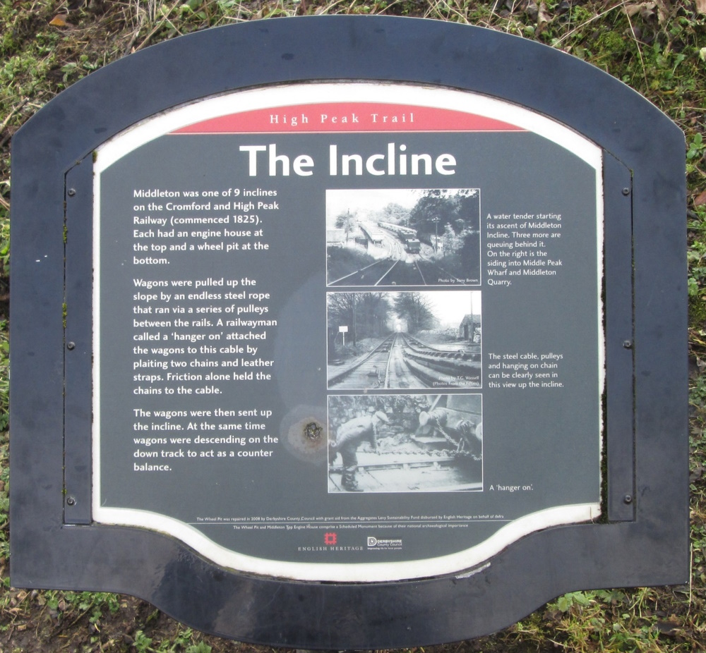
Another incline - one of many on the High Peak Trail

Distant view from the High Peak Trail of Arkwright's Willersley Castle

The Catch Pit, designed to stop runaway waggons before they reached the High Peak Junction and Cromford Canal 

Approaching High Peak Junction

"The world's oldest surviving railway workshop"

Our route back over the swing bridge on the canal
Wheatcroft Wharf Cafe - nearing the end at Cromford Wharf

Off route - fine waterwheel in Cromford

10½ miles, 660m of ascent - more than Ben Nevis this weekend