Records of rights of way problems
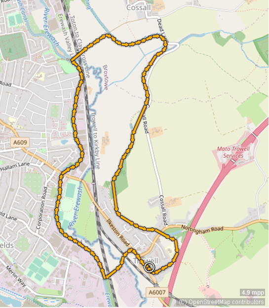
Ramblers HQ (RHQ) has made available a list of rights of way (RoW) problems in the Nottinghamshire Local Authority area dating back to 2018 and locations or waypoints of these problems are displayed on the interactive, OpenStreetMap map below. This data, generated by members using the Pathwatch application (discontinued August 2022) and in the form of a .csv file, was sent in response to Nottinghamshire Area Ramblers' campaign to improve accessibility of RoWs particularly by repairing or replacing stiles. Other data from Notts Area Ramblers has also been made available.
Zoom in and pan the map and click on or hover over a waypoint to see what the problem is and follow links, provided in about half the cases, to see associated photos.
These waypoints and their features can be revealed or hidden by using the See data layers or located using the Browse data menu icons at the top left of the map. The stiles problems are in red (RHQ data) with additional, Notts Area Ramblers data in green. One problems whose status has been updated has been added in a new layer in purple (see later).
Note that there are many duplicate entries in the RHQ data with identical dates, latitude and longitude but different features.
Reporting a rights of way problem
RoW problems can be reported by visiting the websites of the following local authorities ...
... where you will have the option of providing details, uploading a photograph
and receiving feedback by email. However, the general public has no access to the general LA databases. One exception is
Lincolnshire County Council's excellent website for reporting a whole range of problems but it does not specifically refer to RoW issues.
Alternatively, members
can login to the Ramblers
Pathwatch app on a smartphone or online using a desktop, identify the location on a downloaded OS map square and then itemise
features from a menu, include some narrative comment and then upload the information. You can
share the information with others but only if you have a Facebook account. When using the Pathwatch map squares, members can see icons only of their own reports, edit or delete them.
At some interval, RHQ then feeds this information back to the local authority and Nottinghamshire Area Ramblers but not to individual members or Groups.
Regular summaries of UK Pathwatch reports are published by RHQ here with information broken down by categories: intimidating; obstructions; path surface; road crossings; bridges, gates and stiles; finding your way but not broken down by local authority area.
Problems remain with the reporting and improving access to RoWs:
- the multiplicity of databases:
- the live, online Pathwatch app
- its associated spreadsheet sent to the LA
- the Nottinghamshire Area Ramblers' data
- the data reported directly to Notts CC
- the data reported to District Coordinators
- the data reported to RoW Committees
- the poor quality of much of the Pathwatch waypoint data entered - members should be encouraged to make proper use of the Other narrative entries
- when viewing members' own entries: the clunky ways of navigating around the Pathwatch application; the inadequate information displayed
- the poor Ramblers members' access to the data
- the lack of routine feedback regarding RoW updates and/or improvements.
Ideally, the databases should be consolidated into a single one but whether this can be an improved version of Pathwatch remains to be seen. An alternative is to maintain a local database such as the one used to generate the map above and make it available via the Area website.
Locating and updating a waypoint
In the field, walkers with a smartphone can have access to the RoW problems map via this VBR blog. In addition, they will have access to GPS and their location can be made visible using, for example, OpenStreetMap or OS Maps applications so they should have no difficulty locating a particular waypoint.
Members with a tablet with no phone connection but with an account with OS Maps will be able to track and record their progress on a 1:25,000 map provided they have cached or saved the OS map in the vicinity of the waypoint previously when in wifi range. Note that though tracks and routes can be recorded, plotted or uploaded to OS Maps, waypoints cannot be uploaded as they can to uMap. The new desktop version of OS Maps does provide the facility to add labels to individual, uploaded trackpoints but these are not clickable on either the desktop or mobile maps.
Alternatively, the RoW
.gpx file used in the generation of the map (see Technical notes below) can be uploaded to a GPS device where (at least on some Garmin devices) waypoints will be stored in the
Current Track entry. Icons will then appear at the waypoint locations with labels, (albeit truncated in this case to twenty four characters),
as well as being listed in numerical
order or by proximity to the user.
 |
Garmin Waypoint Manager screen -
start of search for #27, 2.67km away |
Thereafter, using Pathwatch, a new set of information can be reported on the spot or later and, if this is fed back from RHQ, the map above can be updated, albeit not automatically.
As a trial, a reported stile problem near the River Smite and next to the Bingham Linear Park was located using the downloaded waypoint .gpx file and a Garmin GPS unit. The stile RHQ reference #27 was reported as being unsafe in February 2019 ...
... but has since been mended.
The problem (or lack of) was reported on Pathwatch and, had it been added to the RHQ spreadsheet, the RoW map above would have looked like this:  |
A (non-interactive) zoomed-in part of the map at the top.
Click the purple waymark on the map at the top then click the link to show the recent image of the stile |
How quickly the RHQ information will be fed back to Nottinghamshire Area to help in the management of these problems remains to be seen.
Stile design
Here is what a good stile looks like - in particular it would have a maximum step height of 350mm, a maximum height of top rail of 1050mm and at least one long grab handle.
Some example of stiles which do not meet this standard can be found by following the hyperlinks below or by clicking the hyperlinks on the labels of some of the waypoints on the map. The # number refers to waypoint data in the RHQ spreadsheet and ## (see map) to the data in the Notts Area Ramblers' spreadsheet.
#17
#18
#19
#26
#28
#29
#31
#39
#160
#161
#169
Technical notes on constructing the .gpx file used to create map
The map above was made using latitude and longitude data together with names made up of comments and dates stored in columns of a spreadsheet and then creating a .txt file in Notepad with one line of text representing each waypoint. If only grid reference data is available, this must first be converted into latitude and longitude using a coordinate converter. Eight figure grid references are preferable as these will give a 10m accuracy.
An example of this html code is shown here.<wpt lat="53.30609035" lon="-0.824984868"><name>#2, Path inconvenient, Unsafe stile, 02-Sep-18</name></wpt>
Some of the Pathwatch data has associated with it photos which are referenced using a hyperlink. If the latter is included in the name as follows ...
<wpt lat="52.998841385" lon="-0.958813923"><name>#2, Open country, 4/20/2021 [[https://reportit.ramblers.org.uk/BPW/Handlers/ImageRetrievalHandler.ashx?fileid=77085]]</name></wpt>
... it will show in the waypoint label. Note the double square brackets [[ and ]] round the link itself which are necessary to make the link active.
The lines of waypoint code then replace similar lines in any existing .gpx file and the file stored with the extension .gpx.
Finally, the .gpx file is uploaded to the application uMap (https://umap.openstreetmap.fr/en/ ) and a map generated. GPS routes or tracks (continuous, unlabelled lines such as the Nottinghamshire boundary) can also be added. The map can be accessed by hyperlink or by embedding in a website as in the case above.
Warning
uMap will upload waypoint data but will stop if it encounters a problem with the html code of the .gpx file. For example, some characters which are permissable in Excel e.g. & must be avoided.
Also, non printing characters, for example Alt Enter which puts a linefeed in an Excel cell and which cannot be made visible, also causes problems which only become apparent: when the lines are copied for editing in Notepad; or waypoints, as seen by the Browse data icon in uMap are missing. The text in the .gpx file must be examined carefully to see that it has exactly the correct format. The presence of the characters "" are a warning that errors have been introduced.
Finally and strangely, some of the Pathwatch data has (automatic?) date entries such as 12/28/22 which have reverted to text in the spreadsheet - 12/28/22. Other data appears with a date format. e.g. 05/08/22 but, does this mean the 5th of August or the eighth of May? Far better to use the format 05/Aug/2022 to avoid doubt.