Hoby, Frisby, Gaddesby and Rearsby, 26th May 2024

Starting near The Blue Bell in Frisby, Rab took 10 members on this 8.8 mile walk following the Leicestershire Round to Frisby and Gaddesby returning through Rotherby on the Midshires Way on undulating Leicestershire farmland.


The start in Hoby

First crossing of the Wreake below Hoby

The Melton Mowbray Navigation was formed when in 1797 the River Wreake was made navigable upstream to Melton Mowbray from its junction with the River Soar near Syston.  Largely river navigation, there were numerous locks built, one near Hoby.
At Melton, the canal joined the now disused Oakham Canal (1802).  Note that, as part of the Active Rutland Walking and Cycling Festival, you can book a place on a guided walk along a 2-mile section in Oakham 

Very passive horses near Frisby

Old Village Cross in Frisby - coffee

Undulating countryside just after crossing the A607 Leicester to Melton road

Field of newly-planted buckwheat with it characteristic arrowhead leaves was seen fully grown in late Summer last year.  It is a short-season cover crop and matures in just 70 to 90 days. It suppresses weeds and attracts beneficial insects and pollinators with its abundant blossoms

St Luke's, Gaddesby - lunch

Brooksby Hall, an agricultural college, now merged with Brooksby Melton College

All Saints' Church, Rotherby

Waterhouse Bridge and the River Wreake in spate

This beautiful brick bridge was built in 1794 by the Melton Mowbray Navigation Company as part of work to make the River Weake navigable from Syston, where it joins the Leicester Navigation, to Melton Mowbray where it linked with the Oakham Canal

 River Wreake looking upstream.  Site of old Hoby Lock   


All Saints' Church Hoby - click here for the sound of the bells.  A similar recording a 1pm in Gaddesby was not so rewarding


Tissington, Parwich, Brassington and Bradbourne, 19th May 2024

Starting in the car park on the Tissington Trail, Dave's walk first visited the sights of Tissington Village before following the Limestone Way as far as the pretty village of Parwich for coffee.  We continued on the Way, then left it near Brassington where we stopped for lunch at the church.  More tracks and fields took us to Bradbourne, down to Tissington Ford and a climb back up to the start.  An undulating walk in limestone country crossing several dales with streams which drain towards Ashbourne and the River Dove. Splendid views all round with hardly a soul in sight, even on the Limestone Way.

Tissington Duck Pond - setting off

Boards soaking in the duck pond to prevent them drying out during the Well Dressing

Town Well, one of many in Tissington which were dressed last week

Tissington Hall

Some of the participants


Saint Mary's Church, Tissington

Out to Parwich on field paths ...

... and tracks in a rolling limestone landscape

Dropping down to Parwich

Parwich Green - drinks stop

St Peter's Church, Parwich

All Saints Church, Ballidon is a redundant Anglican church under the care of the Friends of Friendless Churches.  It dates originally from the 12th century but over the centuries the building has been partly rebuilt or restored

Interior showing impressive chancel arch and, to either side, the Ten Commandments and the Lord's Prayer on glazed tiles

View of Rainster Rocks above a Romano-British settlement and field system

St James' Church, Brassington - lunch

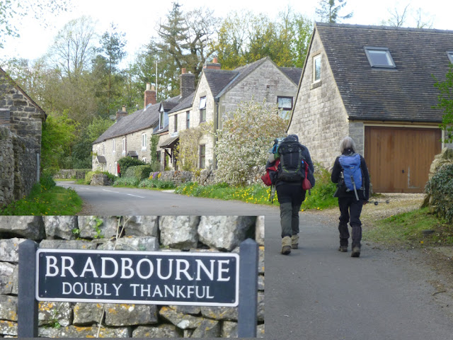
Bradbourne is one of only 14 viilages which are Doubly Thankful having suffered no troop deaths in both World War I and World War II

Bradbourne Mill, the oldest surviving water mill in Derbyshire

Tissington Ford

10 miles


Dove Dale, Ilam, Alstonfield and Milldale, 18th May 2024

In glorious sunshine, Scott's walk explored the high limestone country between Dove Dale and the Manifold.  Starting at the National Trust car park in Dove Dale, we crossed behind the Isaac Walton Hotel to drop down through Ilam to reach the Manifold which we followed for a mile.  The first climb of a strenuous day took us to the highest point (302m) just beyond Castern Hall and was followed by a steep descent into Hopedale and another climb up to Alstonfield for lunch.  Only a few walkers were encountered in the morning but, after returning to the River Dove at Milldale, we had to dodge through the crowds to reach the start.


National Trust's annual event for mausers - to be avoided in future if you value your hearing

Grade II listed Memorial Cross

Church of the Holy Cross, Ilam

Ilam School, one of many fine, listed buildings in a similar style in Ilam

Ilam Hall, now a Youth Hostel

A lot of the Manifold flows from Whetton Mill, under Ilam Country Park and emerges here, leaving the upper river bed higher up the valley dry 

Castern Hall being renovated

Steep descent into Hopedale

St Peter's Church, Alstonfield

Viators Bridge, Milldale

Reynard's Cave high up on the left bank of Dove Dale. Excavations in 1959 indicated that the cave was used as a temporary shelter during the Neolithic, Roman and Medieval periods

Boardwalks in Dove Dale


The stepping stones were "closed" today so we had to take an alternative, tricky route alongside the river

9.5 miles