Dale Abbey, Ockbrook and Stanton-by-Dale, 23rd September 2018

The weather defied the forecast to encourage a good turnout (20) for this nine-mile, varied and undulating walk in countryside tucked in between the industrial areas of Derby and the Erewash Valley and taking in the three interesting villages of Ockbrook, Stanton-by-Dale and Dale Abbey itself.

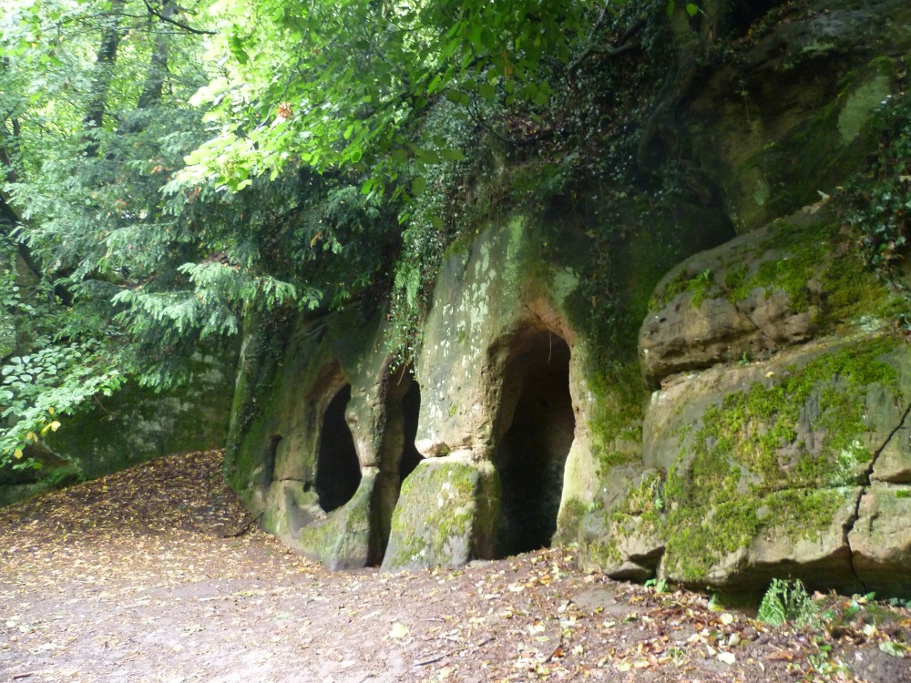
The walk started with a visit to the Hermitage, a rock shelter carved out of the local sandstone in 1130 by a baker from Derby who lived there for 20 years, ...

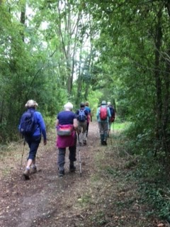
... and continued across fields and through woods ...

... to reach Ockbrook and its impressive Moravian Settlement and school.
Moravian Chapel
In 1750 the Moravian Church, one of the oldest Protestant denominations in the world, established a settlement here, one of only three remaining in the country. The adjacent Ockbrook School was founded in 1799 by the Church.

Leaving Ockbrook we came upon the site where the Risley Park Lanx, a large Roman silver dish, was discovered in 1729. Subsequently lost, the Lanx re-emerged in the 1990s, as a supposed heirloom of the now-notorious art forger Shaun Greenhalgh and his family who made it in their garden shed gang in Bolton.  See here to read about this tale of fake or fortune, much more interesting than the ones on TV.

Over the hill to Stanton-by-Dale.
"The village gave its name to the world famous Stanton Ironworks whose blast furnaces and foundries dominated the valley below for over two centuries.  Founded in 1789 to produce pig iron and, later, iron pipes for water and gas mains, Stanton was the first in the world to produce spun iron pipes in 1921.  Its foundries supplied much of the tunnel linings for London Underground; bombs in World War II; roadway castings across the world.  Stanton joined French producer Saint-Gobain in 1985 creating the largest global iron pipe group in water pipelines.  Local production ceased in 2007 but major national distribution of modern iron pipe remained.At its peak in 1951 the famous company employed 10,000 mainly local people.  This plaque pays tribute to its historical place in British industry and to all those who worked there through the generations."

"Erected in commemoration of the beneficent reign of Queen Victoria, June 22nd 1897, the gift of the women of Stanton"

The route back skirted the site of the ironworks before visiting the remains of the Abbey. 

This was founded by Augustinian monks in 1162 from their previous home at Calke Abbey.  In 1539, the Act of Dissolution brought an end to almost four centuries of monastic life in the Dale.

The walk then went past All Saints Church ... 
... in Dale Abbey village before we retraced our steps through Hermit's Wood to the start.


Malhamdale Weekend Away, 14th to 17th September 2018

Sue and Dave organised and led five walks for the Vale of Belvoir Ramblers based at the HF's Newfield Hall, a grand 19th century country house situated in the Aire Valley south of Malham in the Yorkshire Dales. Below you will find photographs taken on the longer walks.

Map of walk area - zoom in and pan for detail


Saturday 15th

Dave led the longer walk from Newfield Hall along the Pennine Way up the Aire Valley to Janet's Foss and Gordale Bridge before climbing up to the high ground below Malham Tarn.  Return was past the water sinks and down Watlowes Valley to Malham Cove and Malham.
Newfield Hall, our HF base

Our route on Saturday and Monday
Airton Mill, originally the site of a corn mill owned by Bolton Abbey


Overlooking Aire Head, the official source of the River Aire,  Malham Cove in the distance

Gordale Beck leading to ...

... Janet's Foss, named after the fairy queen who inhabits a cave at the rear of the waterfall (allegedly)

Tricky descent down Watlowes Valley, also known as the Dry Valley, originally carved out by the glacial overspill from Malham Tarn

Safely down Watlowes Valley but more wet limestone hazards to come

Limestone pavement with the Cove in the background

The base of Malham Cove

Tea-time? at The Buck Inn, Malham
The way back down the Aire - even the herons look wet


Sunday 16th

Sue took charge on this very wet day taking us to Winterburn Reservoir, up the Dales High Way to Hetton Common and Calton Moor, returning along the Aire Valley.

Water above ...

... and below

Winterburn Reservoir
Liquid lunch - but not as you know it
Heading down Calton Moor

Monday 17th

Today's 8-mile walk took us along the Leeds and Liverpool Canal. This 127 mile canal, one of three across the Pennines, reaches a summit level of 148m.  Started 1770, the main line of the canal was completed in 1816.  In its early days it  carried mainly coal and limestone and did not close to freight traffic until 1982.

The walk started in Gargrave, originally the site of a Roman Villa but now more famous as the junction of the canal, the Pennine Way and the A65 trans-Pennine road.


The start in Gargrave

Gargrave Lock

Bridge 169
Bridge 162


Towpath near the double arched bridge at East Marton, only a few metres below the canal's summit level

The end of the road - Gargrave Bridge over the Aire ...


... and the end of the road for Elaine's boot too.

Woolsthorpe and the Grantham Canal, 9th September 2018

Rose led ten VBR members on this lovely six-mile to Casthorpe Bridge along the Viking Way and the River Devon and back to the Dirty Duck at Woolsthorpe Wharf.


Cuckney and Welbeck, 2nd September 2018

Marion's walk today started next to the church in Cuckney and took us near the historic Welbeck Estate to Norton and Church Warsop in the general vicinity of the Rivers Meden and Poulter.
   
The start at Cuckney Village Hall
St Mary's Church, Norton Cuckney
Cuckney Water Meadows near the River Poulter

Memorial to Lord George Bentinck on Lime Tree Avenue

House made of local magnesian limestone on Welbeck Estate
Pleasant walking in fields and woods

Waves of solar panels
Lunch at the Church of St Peter and St Paul, Church Warsop