Colliers Wood and Beauvale Priory, 26th March 2023


Howard's 7.2 mile walk explored the countryside where D H Lawrence spent his formative years.  We started at Colliers Wood, the site of the old Moorgreen Colliery (1865 to 1985) known as Minton Pit in Sons and Lovers before walking alongside Moorgreen Reservoir to enter Morning Springs Wood, leaving to drop down to Beauvale Priory for coffee.

Lunch followed at Greasley Church before we edged past Moorgreen to return to Colliers Wood.

The start in Colliers Wood Nature Reserve

Lake in the Reserve


Moorgreen Reservoir was constructed at the end of the 18th century to supply water via Beauvale Brook to the Nottingham Canal.  Lawrence renamed it Nethermere in The White Peacock (1911) and Willey Water in Women In Love (1920)

Open countryside in the valley of Beauvale Brook, the feeder to the reservoir

Leaving Morning Springs Wood
Nearby is Robin Hood's Well and the remains of a gamekeepers cottage which features in Lawrence's Lady Chatterley's Lover

Approaching Beauvale Priory.

Beauvale Priory, founded in 1343 by Carthusian monks and the inspiration for D H Lawrence in A Fragment of Stained Glass.
Inscription reads:
St John Houghton and St Robert Lawrence
Martyed 4th May 1535
Priors of Beauvale Priory
Martyrs of England and Wales

Beauvale Priory Farm

Coffee stop next to Beauvale Priory

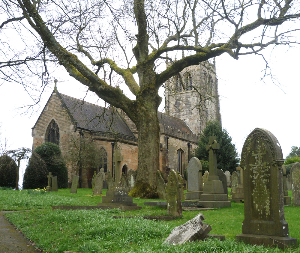
St Mary's Church
Some of the happiest days were spent haymaking in the fields opposite the south side of  Greasley Church, D H Lawrence

Lunch behind the church with distant views of IKEA

Return to Colliers Wood

Old mining equipment near the end


Elkesley, Bothamsall and Hardwick Village, 19th March 2023

 Dave's 9½ mile walk took sixteen ramblers firstly through Bothamsall to its motte and bailey castle for coffee before rejoining the Robin Hood Way to continue into Clumber Park and down to Harwdick Village for lunch.  The return followed the River Poulter back to Elkesley.

Thanks Steve for the photos.


The start at St Giles' Church, Elkesley

Bridge over the River Poulter near Elkesley

River Poulter overflowing the footpath.  Easy passage today but sometimes a foot deeper after heavy rain

Our leader


Bothamsall Hall built by the Duke of Newcastle

Wind pump in Bothamsall

Our Lady and St Peter's Church, Bothamsall

Attractive Village Hall

Castle Hill, aka Bothamsall Castle, is a Norman (or Saxon) motte and bailey castle (but without a bailey) - coffee stop

View from Castle Hill.  In the middle is a bridge over the River Meden and in the distance the River Maun; both rivers join the River Poulter near Elkesley to form the River Idle which joins the Trent at West Stockwith 

Signs of current oil or gas extraction from the Bothamsall Oilfield

Capped-off oil well (see map below)

Approaching the A614 on West Drayton Avenue, part of the Robin Hood Way.  The Avenue was one of the favourite drives of the Newcastle family and stretches from the Clumber Lake to their mausoleum at Milton near the A1

Entry to Clumber Park near the A614

Descending to Hardwick Village

Clumber Lake and Hardwick Village

Washed away footbridge near the ford nessitates a diversion

Outfall from Clumber Lake

River Poulter and Clumber Wetlands

Hardwick Village - lunch

Bridge over the Poulter at Crookford - section of the alternative 8.6 mile route in the event of wet weather

Today's route in orange and an alternative when the path near Elkesley is underwater.  The red dots are locations of oil wells on the Bothamsall Oilfield


Epperstone towards Halloughton Dumble

 Elaine's 6¼ mile walk took 19 VBR members and visitors from outside the Cross Keys in Epperstone up Hagg Lane and across several becks and dumbles to reach Bankwood House on high ground above Epperstone.  A good road took us towards Hollybeck Nurseries and Halloughton Dumble before we dropped back down to Epperstone for lunch at the Cross Keys (for some).
The start outside the Cross Keys
Epperstone Pinfold
 Pinfolds go back 500 years and were built to hold stray animals. The animals would not be released until a fine had been paid. They were also used by drovers taking their stock to market.
Restored by the Buckland family in 2009 with help from Nottinghamshire County Council and Newark and Sherwood District Council

Looking back at a misty, moisty Epperstone

Hill Farm wind turbine - an unusual machine with the two rotor blades downwind of a guyed tower and which can be erected using a ground level winch.  This 275kW turbine was planned to generate "approximately 480 MWh of electricity per annum, sufficient to provide electricity to 112 residential dwellings, based on a capacity factor of 20%"


Approaching Bankwood House

Bankwood House

The line of the infamous Severn Trent water pipeline which in 2016 caused a sinkhole to appear in Epperstone

Back in Epperstone - the Dovecote (1690)