Wymondham, Sewstern and Edmondthorpe, 29th August 2021


Steve's nine-mile walk explored the Leicestershire/Rutland border taking 24 of us from the Berkeley Arms in Wymondham along field paths and good tracks to Sewstern and then along sections of the Viking Way and the Rutland Round to Edmondthorpe and back to Wymondham.


Steve welcomes several newcomers at the start

Signs on pub in Sewstern

Holy Trinity Church, Sewstern

Good tracks (with a few exceptions)

Edmondthorpe Pump and Social Club.

Unusual pump with spout in the form of a dragon's head. WAP stands for William Ann Pochin (1844-1901) who was Lord of the Manor

Another pump in Edmondthorpe with access from both sides of the wall

St Michael and All Angels Church, Edmondthorpe

And back to the Berkeley Arms ...

... for a pint with our leader


Fiskerton, Staythorpe, Upton and Rolleston, 22nd August 2021


Phil led twenty three VBR members on this nine-mile walk starting in the car park next to the Trent at Fiskerton.  After following the river as far as the power station, we turned northwest through Staythorpe Village and across the railway to reach Upton, famous for Upton Hall, the home of the British Horological Institute.


The start at Fiskerton


Entrance to Farndon Marina

Excellent fishermen's tracks alongside the Trent

Staythorpe Power Station cooling water inlets

 
Phil takes centre stage as usual

Crossing Car Dyke

The promised rain approaching as we approach Upton

Upton village sign suffering the ravages of time

Upton Hall, British Horological Institute and Museum of Timekeeping

St Peter and St Paul's Church, Upton - socially distanced lunch in bubbles

After lunch at the church, we followed the River Greet past Southwell Racecouse and Southwell Golf Club back through Rolleston to Fiskerton.

Southwell Racecourse all-weather track and grandstand

Late 18th century, Grade II listed Rolleston Mill on the River Greet

The Kate Greenaway Trail, Rolleston

St Mary's Church, Rolleston

Fiskerton Mill (1790 to 1921) on the River Greet

A wet end to the walk in more ways than one


Bradwell, the Hucklows, Bretton and Shatton Moor, 15th August 2021


Today's 11-mile walk was the first in the Peak District since March 2020 and (almost) filled in a missing link between the walk to Eldon Hole in 2019 and one from Eyam over Eyam Moor and Sir William Hill in 2015.  Six on the walk which is two more than other walkers we saw on the hills all day - who says the Peak District is busy in August?


The walk started in Bradwell ...

... next to Bradwell Brook ...

... and took us up Bradwell Dale and past an old quarry ...

... to Little Hucklow and its newly renovated 12th century pub, The Blind Bull.

The route then took us down to cross the Bradwell to Tideswell road and along an old quarry track with views up to the Gliding Club on the edge of Abney Moor ...


... and to climb steadily to pass Milldam Mine ...

Entrance to Milldam Mine showing unusual wall made out of tunnel roof supports

... to reach Great Hucklow for coffee.
Queen Anne Inn, Great Hucklow

Rebuilt 14th century Great Hucklow Butter Cross

The Old Manse, Great Hucklow

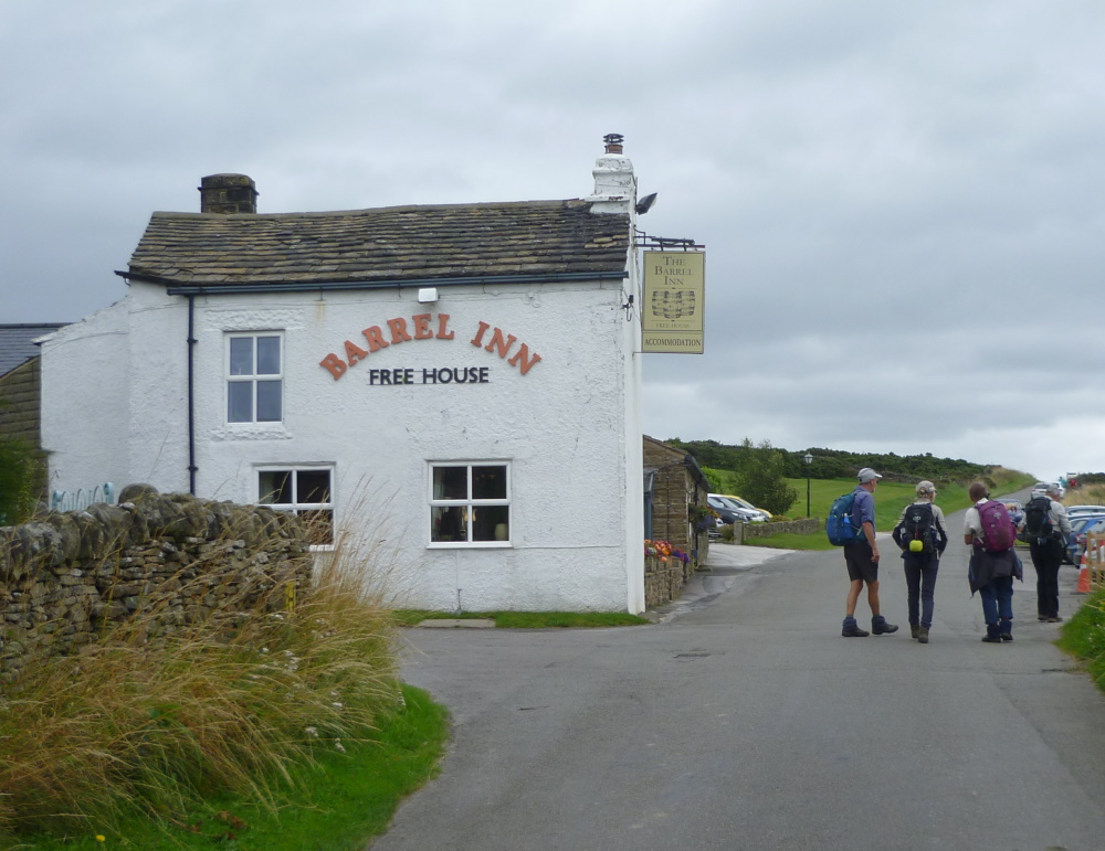
Then we went along a gritstone ridge, with fine views south and west, to Bretton's Barrel Inn, at 380m the highest pub in Derbyshire.

Right on the border of the White Peak and the Dark Peak - limestone to the SW, gritstone to the NE.
If you dug down a few hundred metres you would find the Hucklow Edge Lead Vein which runs from Ladywash Mine  (just south of the Sir William Hill mast on Eyam Moor) to Tideslow, south west of Little Hucklow.  It was first worked for lead by the Romans and recently for fluorspar and barytes.  Mining has created huge caverns including a barrel-shaped one which gives the pub its name.

A steep drop through the bracken took us down to Bretton Clough ...


... followed by a climb up to Abney for lunch.
Abney, heather on Shatton Moor in the distance

Further climbing took us over Shatton Moor with views this time to the north ...
Shatton Moor radio tower

Hope Cement Works, Mam Tor in the distance

Jane's Skyview app - view to the north

Distant view of the Ladybower dam

Hathersage in the distance

... and down to Shatton for a well earned (distanced) rest.

And then it was back to Bradwell via Brough.

Bradwell Brook again