Hartington, Alstonfield and Milldale, 27th October 2019

Where would you rather be than the Peak District on a beautiful, sunny day in October?

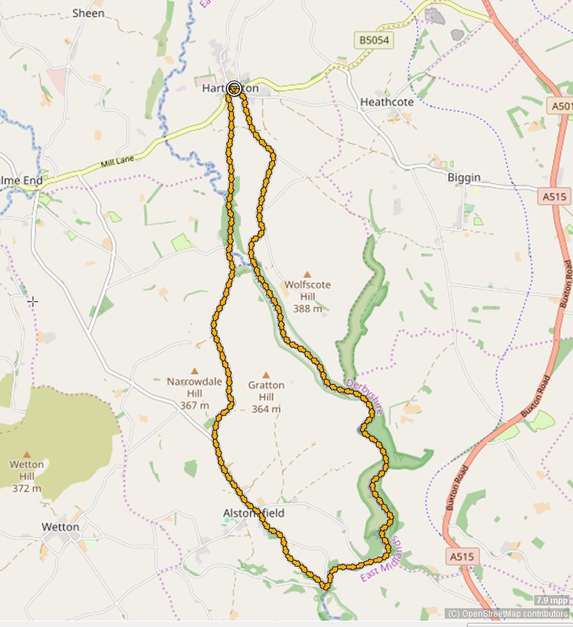
So it was off to Hartington for John's walk to avoid the ash tree felling in the lower Dove Valley (and likely flooding in the Ilam area as well).  We went downriver through Beresford Dale before climbing up to Alstonefield and then descending to Milldale for lunch with the ducks.  Afterwards the route took us up the Dove to Wolfscote Dale before climbing up to Reynard's Lane and back to Hartington. Nine miles at exactly two miles per hour, as always; who needs a GPS?


And if you want to see a 3-d fly-through of the route, go to John's own blog here.
  
The start near the duck pond in Hartington


Old farmhouse in Hartington
Crossing the Dove from Derbyshire to Staffordshire in Beresford Dale.  River Dove in full flood
Climbing up towards Alstonefield and looking back  towards Hartington
Alstonefield Green Well and pump, the main source of domestic water until the mid 19th century


St Peter's Church, Alstonefield


The well-known! Belted Galloway cattle in Alstonefield
Upstream from Milldale
The momentum of the water in the cast iron drive pipe shuts the valve very rapidly once a second and the resulting water hammer pulse drives water up the vertical pipe.  The returning rarefaction wave in the drive pipe opens the valve and the sequence starts again

Biggin Dale in flood

Scree in Wolfscote Dale
Caves above Wolfscote Dale ...
... and here is what you would have seen had you bothered to climb up and have a look inside
View of the Dove and Manifold valleys from Reynard's Lane

St Giles Church, Hartington


Plungar, Belvoir Ridge, Stathern and Harby, 20th October 2019


Rab led this 9½ mile walk from Plungar, across fields and up to the Belvoir Ridge and along the Jubilee Way.  We dropped down Toft's Lane to Stathern then Harby for lunch and strolled by the side of the Grantham Canal back to Plungar.

The start outside St Helen's Church

Tough going, but could be worse after the heavy rain during the week

Easier going before the tricky ascent into Stathern Wood and up to the Belvoir Ridge

Attractive ironstone building in Stathern

Attractive brick building in Stathern - Vale Engineering

Lunch at St Mary the Virgin Church, Harby

Bridges 44, 45, 46, 47, 48 and 49 (just visible) in various states of repair


Rotherby, Gaddesby and Frisby-on-the-Wreake, 16th October 2019


Janets's 8-mile walk today started near All Saints Church, Rotherby and took us across fields and tracks to Brooksby, Gaddesby and Frisby-on-the-Wreake making use of the Midshires Way and the Leicestershire Round.  Soggy in parts but drying out quickly after very heavy overnight rain and flooding on the Wreake.

All Saints Church, Rotherby


Rotherby's mid-eighteenth century Village Pump, restored in 2016


St Luke’s Church, Gaddesby - coffee stop


Medium-size wind turbine with blades downwind of the tower - lunch stop nearby

Frisby's 14th century cross (minus its cross-head)

Last leg

Church Warsop, Cuckney and Norton, 13th October 2019

Just seven ramblers gathered at the start of Sue’s Walk in The Carrs car park in Church Warsop despite the very heavy rain which had deterred many sensible people from walking! Sue took a vote and there was unanimous support to continue.

The walk passed St Paul’s and St Peter's Church before crossing fields to Cuckney. Despite the rains the field conditions were good and many of the walk paths were dry tracks with no stiles to climb.

A coffee stop was taken at the Church of St Mary in Norton Cuckney. Later we passed a huge area of solar panels shared with sheep who use the panels for shelter and keep the grass short.

Lunch was taken sitting on logs at the edge of Sherwood Forest. The rains gradually stopped and we finished in the dry completing nearly nine miles.


A wet start

St Paul’s and St Peter's Church

Sue's in charge

Coffee stop

Cuckney Water Meadows near the River Poulter

Monument commemorating Lord George Bentnick, a past local landowner.

Wave power - I think not

Lunch

Bunny and Bunny Hill, 6th October 2019

Roger led fourteen ramblers on this morning, six-mile walk from Bunny.  He explained that Bunny was listed in the Doomsday Book and the name infers ‘an island’ in the local wetlands.

Despite the recent very heavy rains, Roger kept the walkers to dry paths and out of deep water.  The dull weather turned sunny and we enjoyed a coffee stop with views across to East Leake. 

Afterwards we enjoyed a pint at the local Rancliffe Arms.

Walk briefing
 

Coffee stop

Almost back
Bunny Church